According to the World Economic Forum in its 2010-2011 World Competitiveness Report, El Salvador is first in Central America in terms of Quality of General Infrastructure and Roads, and second in Latin America only after Chile.
ROADS
El Salvador has a total of 6,453.01 km (4,009.71 miles) of roads. 3,377.90 km (2,098.93 miles) of roads are paved and 3,075.11 (1,910.78 miles) are unpaved.
El Salvador has achieved this positioning through consistent and continuous investments from FOVIAL, the fund specifically created for road maintenance which charges $0.20 USD for each gallon of fuel. The main arteries in El Salvador are the Pan-American Highway and the Litoral Road (Coastal Highway). The first crosses the country from Guatemala to the eastern border with Honduras, connecting the main Salvadoran cities: San Salvador, San Miguel, and Santa Ana.


AIRPORTS
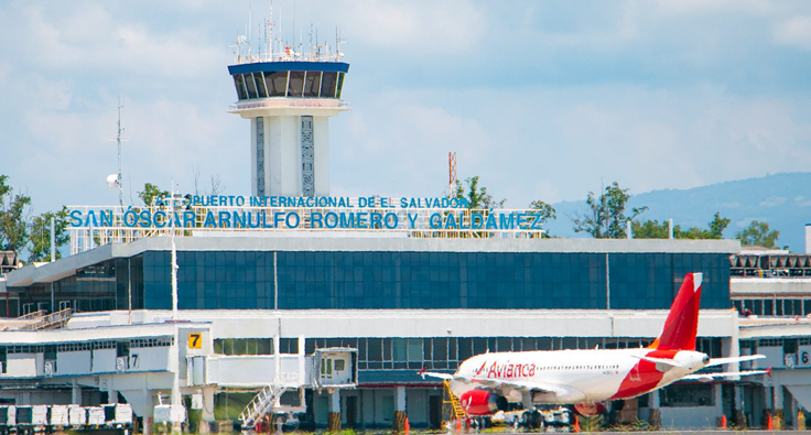
El Salvador International Airport (AIES) is strategically located outside the city of San Salvador and 31 meters (101 feet) above sea level. It is located in Comalapa, 42 kilometers (26.1 miles) from San Salvador (traveling time is approximately 40 minutes). Thanks to its location, it has 100% visibility all year round and optimal take-off capacity with load. The airport has 17 gates, in the main terminal and 3 in the cargo terminal.
AIES has the A1 certification by the Civil Aviation Authority (AAC equivalent to FAA) and according to the World Economic Forum in its World Competitiveness Report 2010-2011, El Salvador has the third best airport infrastructure in Latin America only surpassed by Panama and Chile.
Ports
- Currently the only operational port in El Salvador.
- Constant growth of 20% in the last 5 years.
- In 2008 it moved 4.8 million MT and 166,000 TEU.
- 70% bulk - 30% containers.
- 79 blocks for extra-port development.
- Docks: Total docking frontage of 1,300 meters (0.8 miles); Its depth varies from 8 to 12 meters. (16 to 40 feet).
- Construction: May 2005 - Feb 2009 by TOA-JDN, JV
- Investment: US$200 Million
- 117 hectares (290 acres) of land
- 36.2 Ha (89.4 acres): port infrastructure
- 80.8 Ha (200 acres): Industrial and commercial use
- Depth of 15 meters (49 feet) with the power to receive “POST-PANAMAX” container ships of up to 7,500 TEU
- Capacity Phase I: 550,000 TEU Phase II: 700,000 TEU
